Weather was not kind to us at the Fox Glacier, and after waiting for 1 ½ days, we had to give up the idea of taking the helicopter ride over Mt. Cook with a landing on the Fox Glacier. However we made the best of our time and took 4 hikes. First we hiked up to the edge of the glacier – a very easy 1 hour hike. Getting that close to a glacier was a pretty awesome experience even though the clouds brought steady rain. Our Goretex jackets served us well and the rain added to the atmosphere. I took numerous photos of all the warning plaques. If you thought there were lots on the Hawaii Beaches...
Next we tackled Gillespies Beach hiking for about 3 hours. We drove about 14km down an unsealed (NZ for gravel) road. This was a gold mining area in the first half of the 20th century. The site was abandoned in 1945 having never been profitable. One can view the massive gold dredger equipment scattered around the site, great rusting hulks so out of place in the landscape. The tough coastal vegetation is reclaiming the land, filling in the terrible scars.
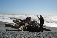
My favourite part was hiking on the beach covered in volcanic sand. large rocks and smooth pebbles. I searched diligently for pounamou, the native jade, so valued here. The Maori traded this beautiful stone with the Europeans (pakehas) for tools, weapons etc. I love collecting rocks and there were so many beautiful possibilities! After much deliberation, I picked some smaller green specimens as I must lug them in my too small suitcase. If they are not pounamu, I don’t mind, they are still beautiful.
These west coast beaches are my favourites in NZ; they are vast desolate stretches pulverized by the Tasman Sea. We walked all afternoon and met only 2 other people; we waved at them as speech was impossible. The wind was absolutely wild and the surf thundered relentlessly, grinding the stones into smooth ovals of all sizes. There are no surfers or swimmers on these stretches – too dangerous. I couldn’t help but think with a shudder how terrible it would be to walk out just 3 feet into this maelstrom certainly to be sucked into oblivion. Unlike Hawaii, there are no danger signs posted anywhere. No one would be foolish enough to venture out there unless intent upon suicide.
I was thinking of Tony Horwitz’s book, Blue Latitudes: Boldly Going Where Captain Cook Has Gone Before recommended by my Canadian-Australian friend Keila. It was the perfect book to read in preparation for this trip. The author followed Captain Cook’s routes comparing his own present day experiences of place to those of the infamous navigator. This is definitely Captain Cook territory here. We visited Cape Foulwind the day before. As I stood looking at the furious ocean, I couldn’t imagine how the early sailors were able to navigate these waters with no technology, guided by the stars or how Cook survived long enough to take 3 separate journeys. The Polynesians on the Big Island of Hawaii finished him off, not the unpredictable South Seas.
We were literally blown along Gillespies Beach to Gillespies Lagoon, where we took refuge from the stinging winds and blowing sand. Water here was calm and warm; I could have stayed a long time. Duncan perched on a driftwood log while I washed my pounamou in the lagoon and compared my little treasures, reluctantly abandoning at least half of them. From there we crossed a bridge and entered a spooky primeval looking forest to hike to the Miner’s Tunnel, a claustrophobic 50 metre long opening that had been blasted into the terrain to give the miners access to the water. At the end is a barrier and on the other side that pounding surf.
No amount of cajoling would persuade my partner to continue on for 1 more hour to reach the next beach, where we might have seen seals. So we retraced our steps, almost blown off our feet along the stretch of now familiar beach. He was probably right, it might have been tough to find the trail off the beach at dusk.
As my skin and hair were redolent of eau de mer and my ears were gritty with sand, we returned to our B & B, where I savoured a long hot shower. We shared a plate of fish and chips and sampled another kind of Moa Beer at The Plateau Restaurant before embarking on the Lake Matheson Trail in order to photograph Mount Tasman just before sunset. Finally all the clouds had blown away and had we been lucky enough to book a very late afternoon helicopter ride, we would have reached our desired destination. A vigorous 1 ½ hour hike around the lake, most of which takes place out of sight of the lake, rewarded us with occasional views of the peak and glacier we were unable to visit by air. We took photos and were able to see the peaks reflected in the waters below.
We enjoyed the hike so much we arose before dawn to repeat the process, rewarding ourselves with flat whites at the Lake Matheson Cafe before returning to Mountain View B & B for breakfast. We really thought we’d be able to take our copter ride, but the fiendish clouds filled in again before 10:45, and we abandoned our plans and headed out for the 4 hour drive to Lake Wanaka.


No comments:
Post a Comment